4D Ocean Hurst Point ASV Survey
- 2017-09-20
- By admin
- Posted in Hydrographic survey
Assisting @dmallace of 4D Ocean with an ASV survey at Hurst Point to combine with the UAV survey data acquired two weeks previously. As part of a Channel Coastal Observatory project, the results will be used to monitor erosion of the shingle spit.
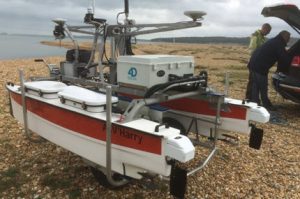
4D Ocean’s ASV Harry is a SeaRobotics 2.5m unmanned surface vehicle used for conducting hydrographic surveys. With an integrated Applanix POS MV and R2Sonic 2020 multibeam echosounder, the autonomous vessel can operate within a 5km wi-fi range. A 6-8 hour endurance at survey speeds of 3-3.5 knots is possible, with remote SV casts conducted using the integrated winch. Transported by road trailer, the deployment cart allows access to remote or inaccessible locations.
Recent Posts
- BP Northern Endurance Partnership Route & Area Survey 20/04/2021
- BP Caspian Shallow Water Pipeline Inspection Survey 13/01/2020
- Equinor Nearshore Pipeline Inspection Survey Project 23/10/2019
- SSEN Pentland Firth HVAC Survey Project 14/09/2019
- Equinor Norpipe Nearshore Pipeline Inspection Survey Project 02/09/2019
Recent Comments
- admin on Marin Mätteknik Culver Sands to Flat Holm Survey
- martin sharp on Marin Mätteknik Culver Sands to Flat Holm Survey
- admin on Marin Mätteknik Culver Sands to Flat Holm Survey
- Arien Kampman on Marin Mätteknik Culver Sands to Flat Holm Survey
- Fred Colebrooke on Marin Mätteknik Lyme Bay – Natural England Survey
Archives
Categories
- Archaeology (3)
- Hydrographic survey (36)
- Other (13)
- Pipeline construction (11)
- Pipeline inspection (14)
- Renewables (8)
- Route survey (10)
- Topographic survey (1)
- UXO survey (6)