Marin Mätteknik Statnett and National Grid North Sea Network Survey Project
- 2012-05-16
- By admin
- Posted in Route survey
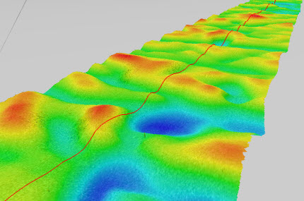
Sub-contracted through NetSurvey to provide Marin Mätteknik AB with specialist multibeam personnel onboard the MV Franklin for the North Sea Network Survey project. This project aims to construct a High Voltage Direct Current (HVDC) electrical interconnector between Norway and the UK. The link would make it possible to combine the hydro-based power system in Norway and the thermally-based generation system in the UK. The corridor survey will provide bathymetric, geophysical and benthic information along the entire 711km proposed cable route. A MacArtney Focus-2 ROTV has been fitted with a dual R2Sonic 2024 multibeam system, together with an iXSea ROVINS inertial navigation system for work in the deeper water. Very high-resolution bathymetry surveys were conducted using the QINSy software package for initial data acquisition and processing, with Fledermaus used for cleaning, surface generation, and visualization.
Recent Posts
- BP Northern Endurance Partnership Route & Area Survey 20/04/2021
- BP Caspian Shallow Water Pipeline Inspection Survey 13/01/2020
- Equinor Nearshore Pipeline Inspection Survey Project 23/10/2019
- SSEN Pentland Firth HVAC Survey Project 14/09/2019
- Equinor Norpipe Nearshore Pipeline Inspection Survey Project 02/09/2019
Recent Comments
- admin on Marin Mätteknik Culver Sands to Flat Holm Survey
- martin sharp on Marin Mätteknik Culver Sands to Flat Holm Survey
- admin on Marin Mätteknik Culver Sands to Flat Holm Survey
- Arien Kampman on Marin Mätteknik Culver Sands to Flat Holm Survey
- Fred Colebrooke on Marin Mätteknik Lyme Bay – Natural England Survey
Archives
Categories
- Archaeology (3)
- Hydrographic survey (36)
- Other (13)
- Pipeline construction (11)
- Pipeline inspection (14)
- Renewables (8)
- Route survey (10)
- Topographic survey (1)
- UXO survey (6)