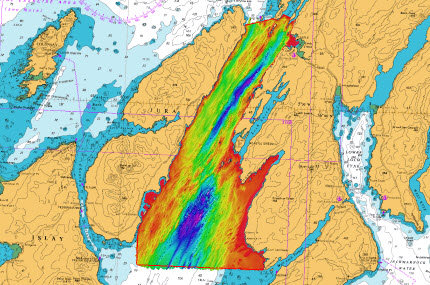
Contracted by NetSurvey to provide a Reports Coordinator for the MCA Sound of Jura Survey. Conducted as part of the ongoing Civil Hydrography Programme, the 524 square kilometre survey area is on the west coast of Scotland, bounded by the Isle of Jura to the west, and Knapdale to the east, extending from Craignish Point in the north to Gigha Island in the south. A steep sided channel runs along the middle of the Sound, with outcrops of bedrock and numerous north-east/south-west orientated ridges clearly visible in the seabed bathymetry data. Two vessels were utilised during the project, with MV Ocean Star (Kongsberg EM2040D) surveying the deeper areas, and MTS Xplorer (dual Reson 7125) concentrating on the shallows. The data was verified using Caris HIPS and Fledermaus, with a Report of Survey submitted to the UK Hydrographic Office along with the processed data to enable Admiralty Chart revisions. High-resolution FM Geocoder backscatter data and seabed samples to support seabed classification have also been submitted.