Contracted by 4D Ocean to provide assistance to @dmallace conducting combined ASV/UAV surveys on Orkney for the SSE Caithness to Orkney Subsea Link Survey project. A number of renewable energy developers in the Orkney Islands have requested a connection to the mainland electricity network, with this new transmission connection requiring initial cable routing and landfall selection surveys.
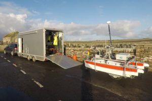
Very shallow bathymetric surveys of the proposed landfall sites were conducted at high water using 4D Ocean’s ASV Harry, a SeaRobotics 2.5m unmanned surface vehicle with an integrated Applanix POS MV and R2Sonic 2020 multibeam echosounder. Transported by road trailer, the deployment cart allows access to remote or inaccessible locations.
Topographic surveys were conducted at low water using 4D Ocean’s eBee UAV, a fully autonomous drone, which is used to capture high-resolution aerial photos that can be transformed into accurate orthomosaics and 3D models using photogrammetric techniques.
Installation of geodetic ground control points was also performed for future geotechnical operations.